|
The quantity (and the cost!) of the nautical charts which are
needed for a circumnavigation is quite impressive! The following list is
based on the Blue water Rally's suggested list, to which I made a few
common-sense additions such as the excellent "Small Craft Folios" for the
Caribbean.
NOTES:
- Most charts are from the British Admiralty's catalog, with just a few from
the US Mapping Agency. French charts are available for some areas in
the Pacific.
- Charts (other than covering local waters) are VERY hard to find anywhere
around the world: buy them before leaving!
- The list does NOT include the charts for the areas to be sailed in order to reach the Rally's route.
- You will notice the lack of small-scale charts, which in many cases quite
simply do not exist! Detailed pilotage information suitable for small
craft was mostly obtained from Pilot Books.
- Despite my additions, there are some glaring omissions, such as the area north
of Viti Levu (Fiji) which would have been an interesting itinerary but was not
covered by the recommended charts!
- Besides the paper charts, we also had a full complement of electronic charts
for our Raymarine chartplotter. We had C-MAP NT, other yachts had
Navionics or C-Map MAX. All charts proved to be generally accurate,
with some exception in the Pacific islands: no system was perfect, and strangely
the errors were often different between the various chart systems!
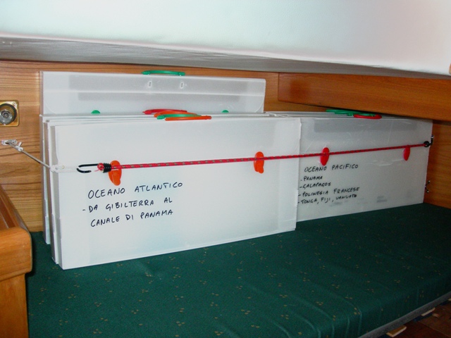
STORAGE:
The whole complement of charts and Pilot Books represent a significant
volume: storing them onboard is a challenge, obviously they would not fit under
the chart table!
Our solution was to store them in several made-to-measure boxes which were then
stockpiled on the bunk in the after cabin.
S/Y SHAULA3 - LIST OF NAUTICAL CHARTS (Total: 132 charts)
Area no. Title
Scale
---------------------------------------------------------------------------------------
UK HYDROGRAPHIC OFFICE
Atlantic Ocean (BWR legs 1 & 2)
3132 Strait of Gibraltar to
Arquipelago de Madeira 1:1250000
3133 Casablanca to Islas Canarias
1:250000
3134 Islas Canarias to Nouakchott
1:1250000
3135 Nouakchott to Bissau and
arquipélago de Cabo Verde
1:1250000
1870 Lanzarote to Gran Canaria
1:300000
886 Estrecho de la Bocayna and
Approaches to Arrecife
1:75000
4012 North Atlantic Ocean
1:10000000
Caribbean & Panama (BWR leg 3)
4402 Caribbean Sea
1:2750000
SC5640 Small Craft Folio: The Virgin Islands
various
SC5641 Small Craft Folio: Sombrero Island to
Montserrat and Antigua various
SC5642 Small Craft Folio: Antigua to Martinique
and Barbados various
SC5643 Small Craft Folio: Saint Lucia to Grenada
various
2191 Morro de Puerto Santo to Cabo
Codera incl. the Outlying Islands 1:300000
1480 Tobago to Tortuga
1:603000
2192 Cabo Codera to Punta Aguide
1:300000
1966 Tortuga to Cabo la Vela
1:814000
2193 Punta San Juan to Punta Macolla
1:300000
2417 Harbours on the North Coast of
Central America
various
1400 Outer approaches to the Panama
Canal
various
1401 Southern approaches to Puerto
Cristobal
various
3098 Panama Canal
1:35000
Pacific Ocean from Panama to Fiji (BWR
legs 4, 6, 7, 8, 9)
1929 Gulf of Panama
1:300000
4051 North Pacific Ocean - South
Eastern part
1:10000000
4811 Mexico to Ecuador
1:3500000
1375 Archipelago de Colon - Galapagos
Islands
1:750000
1640 Plans in the Isles Marquises
various
4607 Southeast Polinesia
1:3500000
998 Ile Makemo to Ile Tahiti
1:750000
3664 Archipelago des Tuamotu
1:1200000
1382 Approaches to Tahiti and Moorea
1:100000
1436 Plans in Tahiti and Moorea -
Port de Papeete
various
1060 Huahine to Maupiti
1:170000
1107 Plans in the iles de la Societé
various
4606 Tonga to Archipelago des Tuamotu
1:3500000
NZ82 Tonga
1:750000
NZ8234 Vava'u Group
1:73000
2691 Fiji Islands
1:800000
440 Fiji Islands - eastern
group, northern portion
1:351000
441 Fiji Islands - eastern
group, southern portion
1:348000
378 Savu Savu bay & Nakama
creek
1:50000
1674 Eastern approaches to Suva
Harbour
1:50000
1673 Western approaches to Suva
Harbour
1:50000
746 Navula passage to Beqa
1:150000
1670 Plans in Viti Levu - Nadi waters
various
Fiji, Vanuatu, New Caledonia (BWR leg
10)
4633 Solomon Islands to Fiji
1:500000
1570 Efaté to Espiritu Santu
1:300000
935 New Caledonia north
1:500000
936 New Caledonia south
1:500000
1494 Efaté and plans (port Vila)
various
4604 Coral and Solomon Seas and
adjacent seas
1:3500000
Australia (BWR leg 11)
4603 Australia - north coast
1:3500000
Aus 250 Plans of Hay Pt and Mackay Harbour
various
Aus 823 Percy Islands to Mackay
1:150000
Aus 824 Penrith Island to Whitsunday Island
1:150000
Aus 370 Percy Isles to Whitsunday Passage
1:300000
Aus 371 Whitsunday Passage to Palm Island
1:300000
Aus 372 Palm Island to Frankland Islands
1:300000
Aus 373 Franklin island to Lizard island
1:300000
Aus 824 Penrith Island to Whitsunday Island
1:150000
Aus 825 Whitsunday Island to Bowen
1:150000
Aus 826 Bowen to Cape Bowling Green
1:150000
Aus 827 Cape Bowling Green to Palm Isles
1:150000
Aus 828 Palm Isles to Brook Islands and Palm Passage
1:150000
Aus 829 Brook Islands to Russel Island
1:150000
Aus 830 Russel island to Low islets
1:150000
Aus 831 Low islets to Cape Flattery
1:150000
Aus 832 Cape Flattery to Barrow Point
1:150000
Aus 833 Barrow Point to Claremont Island
1:150000
Aus 834 Claremont Island to Cape Weymouth
1:150000
Aus 835 Cape Weymouth to Cairncross Islets
1:150000
Aus 839 Cairncross Islets to Arden Islet
1:150000
Aus 292 Adolphus Channel to Prince of Whales Channel
1:75000
Aus 294 Endeavour Strait
1:75000
Aus 299 Approaches to Thursday Island
1:12500
4720 Booby Island to Cape Wessel
1:1500000
Aus 715 Cape Arnhem to Cape Wessel
1:150000
4721 Cape Wessel to Adele Island
1:1500000
Aus 308 Goulburn Islands to Melville Islands
1:300000
Aus 309 Darwin to Penguin shoal (eastern sheet)
1:300000
Aus 26 Approaches to Darwin
1:75000
Aus 28 Port Darwin
1:25000
Java Sea, China Sea, Timor, Bali,
Singapore (BWR legs 12 & 13)
1697 Flores to Timor
1:509000
3296 Harbours and passges in Timor (Kupang)
various
2776 Flores to Kawula
1:110000
Aus 414 Rowley shoals to Lombok strait
1:1000000
3756 Linta and Molo straits
1:87000
3706 Selat Lombok and Selat Alas
1:250000
946 Ports in Eastern Java
various
941b Eastern Archipelago - Selat
Madura to Selat Makasar
1:552000
4508 South China Sea
1:3500000
3726 Selat Bali to Pulau Kangean
1:250000
1066 Java Sea
1:1000000
1312 Singapore Strait to Selat
Karimata
1:500000
2403 Singapore Strait and eastern
approaches
1:200000
3937 Ports in Kepulauan Riau
various
4038 Western part of Johor strait
1:30000
3949 Selat Riau
1:125000
Malesia & Thailand, Singapore & Phuket
(BWR leg 14)
3833 Singapore strait - western part
1:75000
3947 Melaka to Singapore strait
1:200000
1141 Approaches to Melaka
various
3946 Pelabuhan Kelang to Melaka
1:200000
2152 Pelabuhan Kelang
1:15000
3945 Sembilan islands to Port Kelang
1:200000
3944 Pulau Pinang to Kepulauan
Sembilan
1:200000
3943 Ko Tarutao to Pulau Pinang
1:200000
1366 Approaches to Pinang harbour
1:60000
3485 Approaches to Pelabuhan Langkawi
1:40000
3942 Ko Lauta Yai to Ko Tarutao
1:200000
3941 Mu Ko Similan to Ko Lauta Yai
and approaches to Phuket
various
Indian Ocean, Sri Lanka (BWR leg 15)
4707 Maldives to Sumatera
1:3500000
840 Little Andaman to Great
Nicobar
1:500000
813 Colombo to Sangama Kanda
point
1:300000
819 Approaches to Galle Harbour
1:25000
Arabic Sea & Gulf of Aden (BWR leg 16)
4703 Gulf of Aden to the Maldives and
the Seychelles
1:3500000
3323 Male atoll and anchorage
various
1014 Maldives
1:300000
2970 Gulf of Aden - eastern portion
1:750000
6 Gulf of Aden
1:750000
253 Golfe de Tadjoura and
anchorages
various
262 Approaches to Djibouti
various
Red Sea & Suez (BWR leg 17 e 18)
4704 Red Sea
1:2250000
143 Jazirat at Tair to Babel
Mandeb
1:400000
2658 Outer approaches to Jeddah
1:15000
82 Outer approaches to
Port Sudan
1:150000
3492 Approaches to Port Sudan and
Port Sudan
various
157 Red Sea Masamirit to Bab el
Mandeb
1:750000
158 Red Sea Berenice to
Masamirit
1:750000
159 Red Sea Suez to Berenice
1:750000
5501 Mariners' Routeing Guide, Gulf
of Suez
n.a.
2133 Approaches to Port Suez
1:37500
3214 Port of Suez
1:20000
233 The Suez Canal
1:60000
183 Ra's At Tin to Iskenderun (E.Med)
1:1100000
Mediterranean (BWR legs 19 & 20)
183
Ra’s At Tin to Iskenderun (E. Med)
1:1100000
3678 Kriti – north coast Rethimnon to
Kolpos
1:150000
1707 Harbours and Anchorages in Nisos
Kriti including Iraklion 1:10000
176 Cape Bon to Ra’s At Tin
1:1175000
1093 Steno Andikithiron to Steno
Kafirea
1:300000
165 Menorca to Malta
1:1100000
2122 Bizerte to Capo San Marco
1:300000
1703 Mallorca and Menorca
1:300000
1700 Cartagena to Cabo de San Antonio
1:300000
774 Motril to Cartagena
1:300000
773 Strait of Gibraltar to Isla
de Alboran
1:300000
U.S. MAPPING AGENCY
Various areas
26042 San Blas
26063 San Blas
83570 Yasawa Islands
1:350000
|